
Appearance
Layers configured with a URL
kepler.gl 3.3.0-alpha.21 registers twenty-six layer types. Nineteen draw rows: thirteen are in the gallery, three more have sections of their own — a5 and geohash, kepler's other two grid-index layers, in Geometry and spatial indices, and kepler's flowField in Velocity fields — and three are new in the 3.3.0 line, contour and voronoi (3.3.0-alpha.20) and donut (3.3.0-alpha.21), which take points like the aggregation layers. The other seven are configured with a URL rather than with data, so a Grafana query cannot describe one the way it describes a table of points.
Three of the seven are exceptions now, and they are covered elsewhere: a query that returns a link to a cloud-optimised GeoTIFF produces a rasterTile layer, one that names a WMS service produces a wms layer, and one that names a Zarr store produces the panel's own zarrTiles layer, drawn through a tile server rather than by kepler's zarr. See Satellite imagery and other rasters, WMS services and Zarr stores. This page is about the four that are still added by hand — and about adding any of the seven by hand, which stays possible whatever your query does.
| Layer | What it takes | deck.gl layer |
|---|---|---|
vectorTile | an MVT tile endpoint or a .pmtiles archive | MVTLayer / TileLayer |
rasterTile | a raster tile endpoint, or STAC metadata — or a query | TileLayer |
wms | a WMS service URL — or a query | WMSLayer |
tile3d | a 3D Tiles, I3S, Google or Cesium ion endpoint | Tile3DLayer |
bitmap | one image plus its west, south, east and north bounds | BitmapLayer |
3D | a glTF model, placed at each row of a dataset | ScenegraphLayer |
zarr | a Zarr store URL, read in the browser — or a query, as zarrTiles | deck.gl-zarr |
Why the other four are out of scope
A Grafana panel's input is a table of rows. These layers do not have one: their content lives at a URL that the browser fetches directly, and the only thing a query could contribute is the URL itself.
Which, for imagery, turned out to be enough — hence the three exceptions. It is not enough for a 3D model or a pair of corner coordinates, where the layer needs describing rather than locating.
They are also why the plugin's own layer gallery dashboard stops at thirteen. Demonstrating them would mean calling a third-party tile service on every dashboard load, which contradicts the premise that the plugin makes no outbound call to any vendor.
Using them anyway
Nothing stops you. All but 3D come from Add Data → Tileset in kepler's own panel — Vector Tile, Raster Tile, WMS, 3D Tile, Bitmap and Zarr: pick the type, give it a URL, and kepler creates the dataset and its layer together. 3D is the odd one out — it is an ordinary layer over a point dataset, so it takes its model in the layer's own settings. Either way the result sits alongside the layers your queries produce, which is a genuinely useful arrangement — your own data over your organisation's basemap tiles, say.
Three things to plan for.
It is not saved until you save it
Adding the tileset is not enough. Go back to Map configuration → Save current map in the panel options, or the layer is gone the moment the panel is rebuilt — returning to the dashboard from the editor is enough to do it.
The save stores the tileset's descriptor, not its data: its name, field list and URLs, a few lines of JSON. On the next load the panel hands that back to kepler alongside your query results, which is what re-creates the layer. See Map configuration.
A hardened Grafana will block the fetch
These layers fetch over XHR, so they fall under connect-src. With content_security_policy = true you need the tile host in content_security_policy_template, exactly as for a base map:
ini
content_security_policy_template = """… connect-src 'self' grafana.com https://tiles.yourorg.internal …;"""See Install.
The URL is stored in the dashboard JSON. It travels with the dashboard, including to anyone you share it with, and any token embedded in it travels too. Prefer an endpoint that authenticates by network position or by a reverse proxy over one that carries a key in the query string.
That last point is the sharpest difference between adding a raster by hand and letting a query return one. A tileset added by hand is written into the dashboard; a raster a query produces is rebuilt from the query on every load and never saved, so it is the query — with whatever authentication the data source already has — that decides what is reachable.
A COG pasted by hand is read by the panel's raster tile server
The form's Raster tile servers field starts from the panel's Raster tile server option. A Cloud Optimized GeoTIFF's description is asked of the first server in that field, as <server>/cog/stac?url=<cog> (TiTiler's STAC extension), and the tileset keeps those servers for its tiles. With no server in the field the form asks no one, and says that a COG needs a server: set the panel option, or type one in the field. Up to 1.6 the form sent every COG to Development Seed's public demo, https://titiler.xyz, whatever the option said, as kepler's own form does. A query does not go through this form and is unaffected.
vectorTile
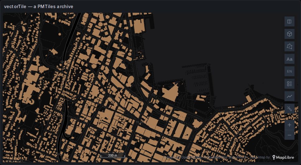
Polygons, lines and points cut into tiles: an MVT endpoint (…/{z}/{x}/{y}.pbf) or a PMTiles archive, which needs no tile server. The image is the New Zealand buildings archive, one of the examples kepler's form offers.
Add Data → Tileset → Vector Tile asks for a name, the Tileset URL — with {x}, {y} and {z} placeholders, or a .pmtiles extension — and an optional Tileset metadata URL (JSON or text), which is where kepler learns the features' properties. For a .pmtiles URL the archive is its own metadata. A PMTiles archive of raster tiles is refused here; it belongs in the Raster Tile form.
The layer colours the fill by a property, with Dynamic Color to fit the colour scale to what is in view; outlines, their colour and width by a property; points sized in pixels or metres; height by a property in 3D; and Hide Null Values to drop features with no value for the fill instead of showing them grey. Hovering shows the feature's properties.
A filter on a vector tile dataset is applied on the GPU, so kepler's filter panel offers only its numeric and boolean properties. kepler records that when the tileset is added but does not save it; the panel puts it back when it restores a saved map.
kepler adds no key or header of its own to the tile requests: a server that needs a key must take it in the URL, which is then saved in the dashboard (see the warning above).
tile3d
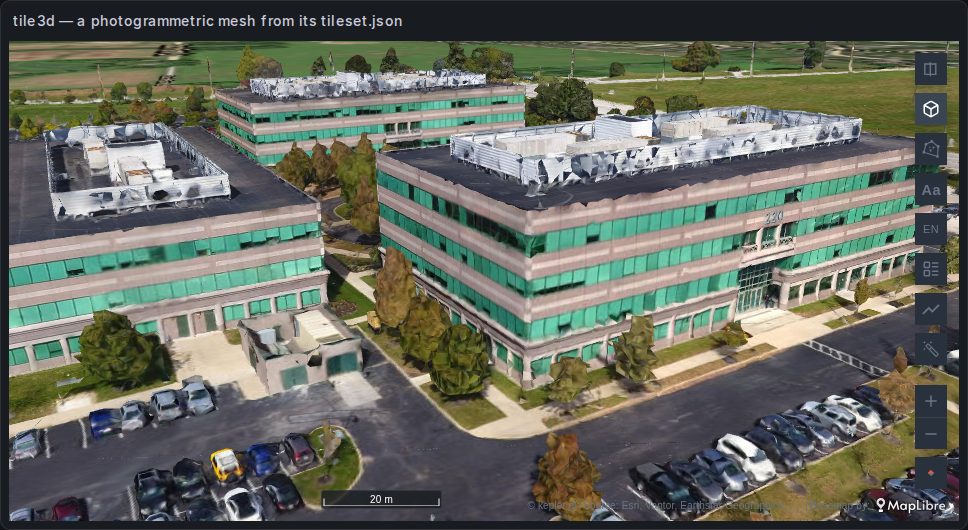
A 3D tileset: a photogrammetric mesh, a city model, a point cloud. kepler reads four kinds and picks by the URL:
| The URL contains | Read as | Token |
|---|---|---|
google | Google Photorealistic 3D Tiles | a Google API key |
ion.cesium | a Cesium ion asset | a Cesium ion access token |
arcgis | an ArcGIS I3S scene layer | — |
| anything else | OGC 3D Tiles, from its tileset.json | — |
Add Data → Tileset → 3D Tile takes a name, the Tileset URL and an Access Token (if needed), with one example of each kind. The image is a public 3D Tiles mesh, drawn from its tileset.json.
kepler's own settings are colour, opacity and point size; colour and point size apply to point clouds. The panel adds a Position group:
| Setting | Default | What it does |
|---|---|---|
| Sit on the ground | on | Brings the tileset's base down to the map's ground |
| Height adjustment (m) | 0 | A trim on top, from −4000 to 4000 m, to lift or bury the tileset |
The map's ground is flat, at height 0, and a tileset states its geometry at its real altitude. A mesh surveyed at 300 m would float 300 m up — and, worse, disappear from any close or tilted camera with no error, because deck.gl culls the tiles it thinks are out of view. The panel puts the base on the ground for that reason. A tileset of buildings round the whole world, like Cesium OSM Buildings, is set down building by building instead.
The panel also lets the camera tilt to 85° rather than kepler's 60°, which a mesh seen from close to the ground needs.
The first time a tileset loads, kepler moves the map to it — except for Google's. A saved map keeps its own saved view instead.
Nothing in a tileset can be hovered: it shows no tooltip.
The access token is not saved with the map
Anyone who can read a dashboard can read its JSON, so saving the map leaves the Access Token out, as kepler's own Export map does. The tileset's URL and name are saved; the token lasts for the session: after a reload, a tileset that needs one draws only once it is added again through Add Data with its token. A dashboard saved with a token by an earlier version still loads with it, and its next save leaves the token out. A key written into the tileset's URL itself is part of the URL, and is saved (see above).
bitmap
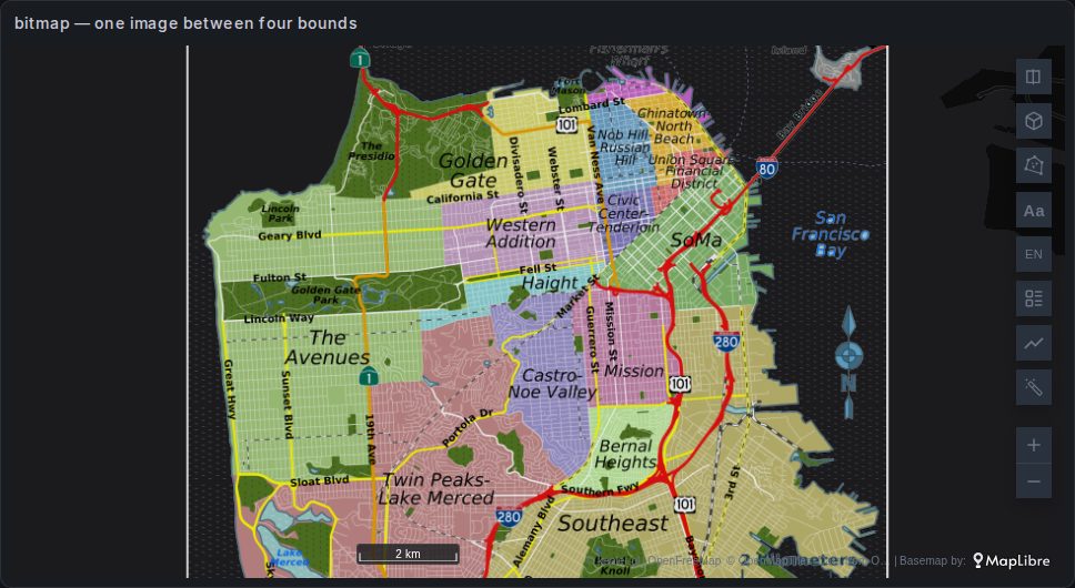
One picture stretched over a rectangle: a scanned map, a plan, a rendered overlay. Add Data → Tileset → Bitmap takes a name, an Image URL or a file dropped on the form, and the rectangle's West, South, East and North in degrees. The image above is deck.gl's sample map of San Francisco's districts.
A dropped file can be PNG, JPEG, GIF, WebP or TIFF, up to 10 MB. It is read into the page as a data: URL — and saved with the map like a URL, so the picture itself ends up inside the dashboard JSON.
| Setting | Default | What it does |
|---|---|---|
| Opacity | 1 | |
| Show Bounds | on | Outlines the rectangle |
| Drag corners to resize, center to move | off | Edit the rectangle on the map |
| Align to map | off | Click a point on the image, then where it belongs; two or more pairs set the rectangle |
| West, South, East, North | — | The rectangle, typed |
The rectangle has no rotation: an image that is not north-up will not line up. The layer has no rows and shows no tooltip.
3D
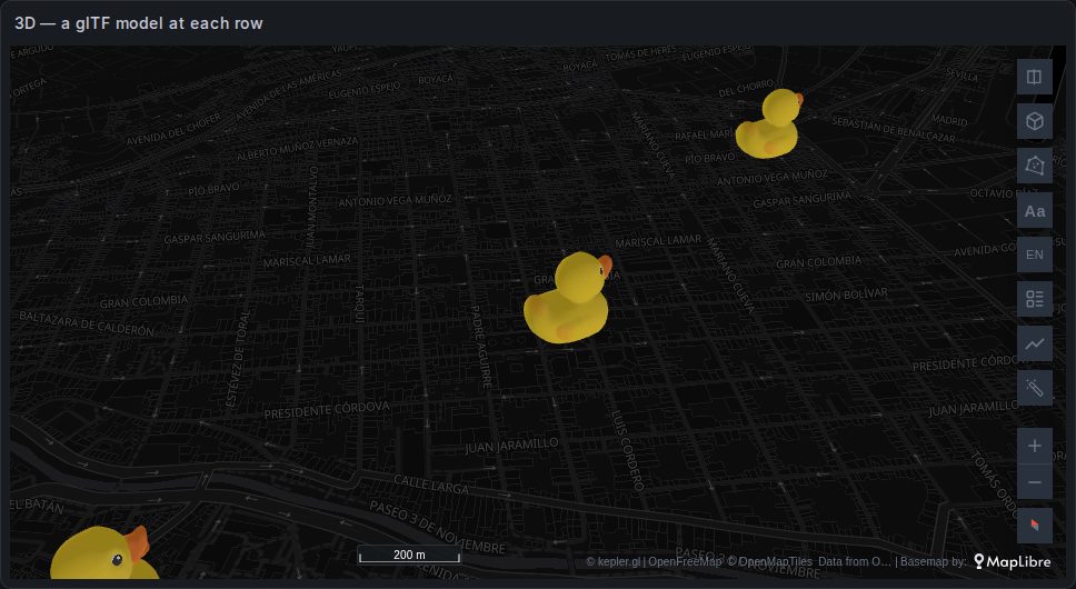
A glTF model drawn at every row of a dataset — a query's points, for instance. kepler never creates it by itself: choose Add Layer → 3D, the dataset, and its Lat and Lng columns (and optionally an altitude), or a GeoJSON column instead.
The model is chosen in the layer's settings: Airplane, Airliner, VTOL, Glider, Helicopter, Bicycle, Scooter, Car, Truck, Semitruck, Cargoship, Ducky — the default, in the image — or Custom, with a URL of your own.
The models come from Foursquare's servers
The built-in models are downloaded from studio-public-data.foursquare.com when the layer draws. A Grafana with no route to the internet draws nothing, and one with a Content-Security-Policy needs that host in connect-src. A Custom model on your own network avoids the first; its host goes in connect-src the same way.
Size, rotation about each axis (angle X, angle Y, angle Z) and a colour (Apply color) are settings of the layer, the same for every row: every model faces the same way. For marks that turn by a column, use Symbols; for a model at the head of a moving trail, the Trip layer.
zarr
kepler's own Zarr layer reads a store in the browser, with no tile server: Add Data → Tileset → Zarr, then the store URL. It is a different layer from the panel's zarrTiles, which a query draws through a tile server. What each costs, and when to use which, is in kepler's own Zarr layer, in the browser.
XYZ tiles
kepler's rasterTile reads PMTiles and STAC, not the plain {z}/{x}/{y} scheme most tile servers publish. The panel adds a layer type for it, XYZ tiles: OpenStreetMap-style servers, ArcGIS MapServer caches, radar overlays. {-y} (rows counted from the south) and {s} or {a-c} subdomains are understood.
There is no form for it in Add Data. It comes from a converted Geomap XYZ or ArcGIS layer (see Coming from Geomap), or from a configuration pasted under Import configuration, which names the template as a dataset and draws it with a layer:
json
{
  "version": "v1",
  "config": {
    "visState": {
      "layers": [
        {
          "id": "seamarks",
          "type": "xyz-tiles",
          "config": { "dataId": "seamarks", "label": "Seamarks", "isVisible": true, "visConfig": { "opacity": 1 } }
        }
      ]
    }
  },
  "datasets": [
    {
      "version": "v1",
      "data": {
        "id": "seamarks",
        "label": "Seamarks",
        "type": "xyz-tiles",
        "metadata": { "url": "https://tiles.openseamap.org/seamark/{z}/{x}/{y}.png", "maxZoom": 18 },
        "fields": [],
        "allData": []
      }
    }
  ]
}
The two warnings above apply: the template is saved in the dashboard, and a hardened Grafana needs the tile host in its Content Security Policy (img-src here, as the tiles are images). The tile server's attribution is not shown on the map; credit it in the panel's description where its terms ask for it.
Base maps are a different thing
Do not reach for rasterTile or vectorTile to change the background. The base map is a panel option with its own list, including self-hosting a MapLibre style.json for an air-gapped install — and it is rendered by MapLibre underneath deck.gl rather than as a deck.gl layer.
See Base maps and relief.